Flying in the Àger area
Àger is home to four main launches. Access to the launches is by a newly surfaced forest road that winds up the mountain in a series of hairpin bends. It takes approximately 30 minutes to get from our base at Campimg Vall d'Àger to the main Coll d'Ares launch.
Raudoral lower launch
|
Raudoral:
Altitude: 1246m
GPS: 31T 312693, 4656422
Height to the Camping landing field: 640 m.
The recently created lowest launch on the first level plateau faces south. Often used early in the morning for an acclimatising fly-down, Raudoral is right next to the access road. It is a smallish ramp that can be used to set up a number of gliders but has only room for single file launching.
It faces South and is the first take off to get the early morning thermals as the rock faces start to heat up. With an easterly wind Raudoral is in the lee so we don't recommend using it in these conditions. Please note that you may have to drive a little further onto the plateau to check wind direction if you suspect an easterly!
|
Gabrieló launch
|
Gabrieló:
Altitude: 1340m
GPS: 31T 315102, 4655761
Height to the Camping landing field: 734m.
This is the 'original' lower launch often known locally as Tablones. There is ample room for hangliders and paragliders to set up.
The access road is now somewhat eroded and unmaintained now that the local schools use Raudoral as their training site. This is quite a technical launch. We only take off from one place and its crucial to check the windsocks before committing to launch.
It faces South and should not be used with any westerly component to the wind. It can be a good take off to use when the North wind prevents launching from the top of Montsec. |
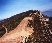
Coll D'Ares main launch
|
Coll d'Ares:
Altitude: 1586m
GPS: 31T 313555, 4657599
Height to the Camping landing field: 980m.
The main launch at Àger, big enough for more than 100 gliders to set up and launch. It faces south but will also take a south-westerly round to west wind by using the shoulder above the shoulder above the road as a start point. In easterly wind it is in the lee, so its better to use the Sant Alis launch further along the road to the east. |
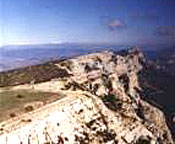
Sant Alis launch
|
Sant Alís:
Altitude: 1675m
GPS: 31T 315237, 4656809
Height to the Camping landing field: 1070m.
Situated at the apex of the ridge Sant Alis offers an incredible panoramic view of the mountains of Montseny, Moncayo, Guara, the Pyrenees from Navarra to Girona, Montserrat, Monte Caro, Prades and the Montsant mountain range.
Tha ramp is no longer in use but paragliders can be launched just to the left. Faces south east. Dangerous in west winds. |
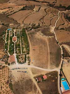
Official landing fields
Vertet Landing Field:
Altitude: 606m
GPS: 31T 315079, 4652814
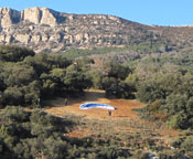
The main landing field next to Camping Vall D'Àger. It is a large rectangular field of 200m x 50 m, oriented west - east. There are windsocks at the western end, but also watch the row of flags next to the childrens play area of Camping for a better indication. Be aware of possible turbulence from the trees surrounding camping in a north wind.
Camp T:
Altitude: 823m
GPS: 31T 313810, 4655000
A huge field at the foot of the cliffs used by the local schools.
Camp Pla de Mates:
Altitude: 720m
GPS: 31T 313660, 4654400
The microlight field at Can Maciarol next to the road up to launch. There is a huge aviation windsock but be aware of light aircraft landing & taking off!
Camp Pla D'Agulló:
GPS: 31T 311841, 4653618
Located on the old road between Àger and Agulló, this is mainly used as a hanglider field. The huge size (300m x 300m) means that it is possible to land in all directions although generally an east-west / west-east approach is preferred. Please be aware that this field is closed while under crops (normally before July)
|
'Vertet' the main landing field
|
A high alternative or emergency landing field is located on the plateau below the main Coll D'Ares launch.
Camp de Tarrits Landing Field: (otherwise known as 'Camp 300')
Altitude: 1289m
GPS: 31T 313452, 4656826
This is a large landing field situated on the plateau below the main launch at Coll D'Ares approximately 300m below the take off. It is used when there is not enough height to clear the front of the plateau. Be aware that thermals breaking off in front of this field may cause either 'dead air' or sudden changes in wind direction.
|
|
|